Posts

Showing posts with the label #excursions. #port

Day 133: Santa Cruz De La Palma - The Canary Islands

Image
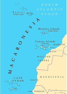
  A fun stop today, featuring volcanoes, wine, and a cute old town high street. The Canary Islands are a set of 7 large volcanic islands between 75 and 200 miles off the coast of Morocco. They’re now a playground for the rich and famous of Europe and Africa, living up to their ancient name of the “Fortunate Isles”.  The Canary name is derived from Roman times, and has nothing to do with cute little tweetie birds, but with dogs (Latin: Canaris = dog as in canine). The birds are named after the islands, and not the other way around!  The islands are between 7 and 20 million years old, and there is still volcanic activity on some of them today. They're reminiscent of Hawaii, as there is a "hot spot" deep underground that slowly slides because of tectonic plate movement, causing new islands to be created. Multiple eruptions have occurred over the last 50 years, and the last major explosion was only in 2021. Driving through La Palma today, there were remnants of lava fields an...

Day 59: Townsville, Aborigines and Cattle Ranches

Image
  Today, we're docking in Townsville, the largest town in Northern Queensland, with a population of around 180,000. The town has a split personality. On one hand its the center of Australian renewable energy projects, on the other its home to a massive zinc and nickel refinery. Historically, Captain Cook sailed past the area in 1770 but did not land. The first Europeans to disturb the native Aborigines were Captain Phillip King and botanist Alan Cunningham in 1819. It wasn't until 1860 that a maritime expedition from Brisbane landed and attempted to settle. The locals met them and greeted them with the traditional smacking of lips. This unsettled a few of the sailors, who thought that meant they wanted to eat them—and they opened fire. Not a great first contact! Undaunted, settlers returned, and the population grew to 4,000 by 1882 and 13,000 by 1891. Ironically, the Second World War put Townsville on the map. During WW2, the city was host to more than 50,000 inhabitants, plus...

Day 56: Bringing Coals To Newcastle

Image
  "Bringing Coals To Newcastle" is a British idiom meaning doing something superfluous. It's used as Newcastle was the coal capital of Northern England, so taking coals to Newcastle was a pointless act. The same is true of Newcastle, Australia - it's the country's coal capital and is the world's largest coal exporting harbour (all 143m tonnes). Most of that coal ends up in China and Japan, ultimately as atmospheric pollutants.  The first European stumbled upon Newcastle in 1797, less than ten years after the Sydney landing of the First Fleet. Lt. John Shortland accidentally found the harbour when in search of a bunch of convicts who had commandeered a small boat, and escaped towards the north. There is no record of if he found the escapees, but he did find a fine deep water harbour  and coal so abundant it was lying on the ground. An initial attempt was made to establish a settlement in 1801, which failed. A few years later, the Brits set up a secondary penal ...

Day 55: The Sydney Harbour Bridge Climb

Image
The two most iconic sights in Sydney are undoubtedly the Opera House and the Harbour Bridge. Today, whilst Allison went shopping for the African segment of our trip, I got to climb the Harbour Bridge. It's quite an experience. You spend almost an hour beforehand getting kitted out, watching safety videos, and practicing ascending steel mesh steps and ladders. At it's height (sorry) you end up 440 feet above the waters of Sydney Harbour. Although you are clipped onto the superstructure the entire way it's still a little daunting to look down through all the steel and realize there is nothing else standing between you and a grim certain death. Throughout the nineteenth century, proposals had been raised for constructing a bridge to link the northern and southern shores of Sydney Harbour. As early as 1815, Francis Greenway (a convict) had suggested to Governor Macquarie the construction of a bridge across the harbour. While this had never formed into anything beyond an idea, i...

Day 54: Arriving In Sydney

Image
This morning, we were fortunate to arrive in Sydney Harbour midway through a bright and sunny day. We spotted the cliffs of Manly from quite a distance away and stood on deck as we passed the Hornby Lighthouse, Bradleys Head, and Fort Dennison. We had a fabulous view of the Opera House on the port side and then passed under the Harbour Bridge on our way to White Bay. As sail-ins go, it was quite impressive. So, as usual, we need a bit of history before we get to our activities. Sydney was named after Lord Sydney, the British Home Secretary, when Captain Arthur Phillip and the First Fleet arrived in January 1788. Phillip described Sydney as "having the most perfect harbour in the world" in which "a thousand sail of the line may ride in the most perfect security." The First Fleet comprised 1,000 people, of whom 736 were convicts. The impetus for these activities was the loss of the American colonies, and Britain needed somewhere else to send their criminals! Well befo...

Day 51: Wellington, NZ (The City, Not The Boot)

Image
Wellington is the capital city of New Zealand, located at the extreme southern end of the Northern Island. Even though it is the seat of government, it's only the 3rd largest city, with a metro population of about 450,000 (less than 10% of total pop). It's been the capital since 1865, but that is not enshrined in any legislation. That's just by general agreement. Can you imagine any other country doing that based on a handshake? Trivia answer here: it's also the most southern capital of a sovereign state at 41.3 degrees. Yet, leaving the bay, you can see the Southern Island barely 15 miles away! It's also the world's windiest city, with average wind speeds of 17 mph. Before European colonization, the area in which the city of Wellington would eventually be founded was seasonally inhabited by indigenous Māori.  Wellington and its surroundings have been occupied by various Māori groups since the 12th century.  Kupe was said to have stayed in the harbor from c. 925...

Day 49: Tauranga, New Zealand

Image
Today, we visited Tauranga. It's a city about halfway down the eastern side of the North Island. Demographically, it's the fifth largest city in NZ at 161,000 and is growing fast. Although it's known for trade, business, and a huge harbor - it's famous for two things. First, it is a surfing and beach paradise. Together with its cousin, Maunganui, it features a massive beach used for national volleyball and lifeguard competitions. Second, it is the Kiwi capital of the country. That's kiwi, as in the fruit, not the bird or the people. So, true, we visited on a Saturday, but the beach was jammed with food trucks, commercial tents, and the tents of local surf and swim clubs. There is not a parking spot to be found. Allison described it as a high-class Jersey Shore town. The Bay of Plenty, where the town is located, was the first landing spot of the  Maori back in the late 1200s. You can understand why they settled here with a temperate climate, sheltered harbor, and ple...